

Is school open? More than 100 schools are closed. Get the school closings here.
The first winter storm of the season is impacting the southern half of the Philadelphia viewing area Monday. This storm has the potential to deliver the biggest snowfall in years for parts of southern New Jersey, central and southern Delaware and Jersey Shore points. Some places could even get a foot of snow. Neighborhoods to the north could get next to now snow on the ground.
The NBC10 First Alert Weather team has issued a First Alert until 5 p.m. Monday for Philadelphia, Delaware, South Jersey and the Jersey Shore due to the chance of at-times heavy snow and a moderate threat of coastal flooding. The snow in some neighborhoods could last until early evening.
NBC10 The First Alert is for snow in Philadelphia, South Jersey and Delaware on Monday.
Rain or rain mixed with snow started before daybreak across far southern New Jersey and Delaware. By 5:30 a.m., icy snow began to fall on the Atlantic City Boardwalk.
As the storm system lifts north and intensifies, heavier bands of rain and snow mix will rapidly change to heavy wet snow. Several very heavy snow bands with snowfall rates of 1″+/hour are likely across South Jersey, central and southern Delaware and the shore points. The intensity of the snow will allow it to quickly accumulate during the morning and into the afternoon hours.


Be careful driving on roads as slick spots should be expected, even in spots where a lot of snow doesn’t fall.
Central and western areas of South Jersey are likely to receive 1 to 6 inches of snow. Widespread snow totals of 6 inches or more are expected as you move to more southern parts of South Jersey, central and southern Delaware and the shore.
Some places just west of the Garden State Parkway may exceed 9 inches of snow and get up to a foot of snow or more. Snow may mix with rain along the immediate coast along (barrier islands), so snow totals should stay in the 6 to 9 inch range. Driving conditions will be extremely poor and people should just stay home and work from home if they can.
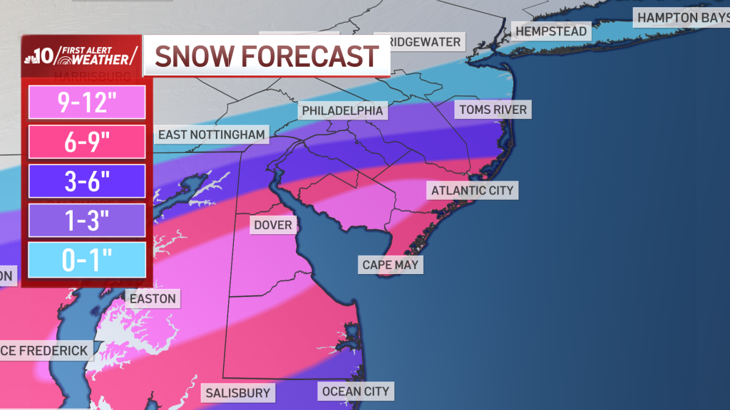
NBC10 Some areas could get a foot of snow Monday. Others won’t get much.
Closer to Philadelphia, the storm will be far less impressive. The snowfall amounts will RAPIDLY drop off and snowfall of 1 to 3 inches at best are expected.
It’s conceivable with warm ground and lighter snow rates, nothing sticks on Philadelphia roads for much of the storm. Briefly through the morning, with a few steadier snow bands, some messy or slushy conditions are possible around Philadelphia. That range of 1 to 3 inches is expected along much of the I-95 Corridor. However, around Wilmington, Delaware, the totals will fall on the high end of the range. The range of 3 to 6 inches will sit just south of Wilmington in New Castle County.
Snowfall totals will rapidly increase as you head east of the I-295 corridor. While neighborhoods near and north of Philadelphia will only see 1 inch or less, 25 miles southeast of the city look to receive widespread totals of 6 inches or more. That’s how sharp the gradient will be.
See It, Share It: You can send photos and video of the snow in your neighborhood by clicking this link.
In addition to the snow, strong wind gusts of 30 to 45 mph are possible late Monday morning through early Monday evening across Delaware and New Jersey and at the shore. The strongest gusts will be felt right along the coast during the afternoon.
A Coastal Flood Warning is in effect for tidal areas in Atlantic and Cape May counties in New Jersey and Sussex County in Delaware until 1 p.m. Monday for the high tide cycle.
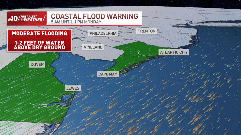
Moderate coastal flooding is possible in coastal Atlantic, Cape May, Kent, and Sussex counties. This means salt water may be 1 to 2 feet above dry ground in vulnerable areas.
A Winter Storm Warning is in effect for central and southern Delaware as well as South Jersey until at least 4 p.m. Monday.
Ahead of the storm, New Jersey Gov. Phil Murphy announced he would issue a state of emergency Sunday night for Ocean, Cumberland, Cape May, Burlington and Atlantic counties.
“Residents should stay off the roads, remain vigilant, and follow all safety protocols,” the Democratic governor said.
NBC10’s Miguel Martinez-Valle reports from Washington Township, Gloucester County, before daybreak Monday as snowflakes fall.
The worst of the storm is over before 5 p.m. After that it gets very cold with lows in the teens Monday night. As a result, icy conditions are expected on roads and sidewalks that are left snowy or wet.
Tuesday and Thursday look quiet and chilly. Wednesday is milder with a few showers. Friday we have the potential for another winter storm, but details are extremely uncertain this far out.
The forecast shifted dramatically from 24 hours ago, due to the track of this storm. It may yet shift again. To stay aware of the changes and receive important weather alerts, make sure to download the free NBC10 app and watch our meteorologists’ forecasts on all platforms.
Monday: Heavy snow parts of NJ & Del. Light snow in City. Mainly dry suburbs & Lehigh Valley. High 34
Tuesday: Mostly sunny. High 36
Wednesday: Mostly cloudy. Chance of a shower. High 44
Thursday: Partly sunny. High 40
Friday: Snow or a wintry mix possible. High 34
24World Media does not take any responsibility of the information you see on this page. The content this page contains is from independent third-party content provider. If you have any concerns regarding the content, please free to write us here: contact@24worldmedia.com