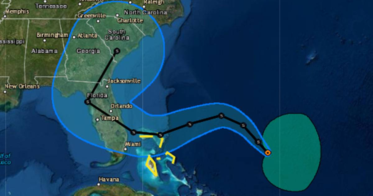
Subtropical Storm Nicole formed Monday morning in the Atlantic Ocean with a projected path that could bring it to Florida’s east coast by Wednesday night near hurricane strength, according to the National Hurricane Center.
As of 8 a.m., the system was located about 520 miles east of the northwestern Bahamas with maximum sustained winds of 45 mph moving north-northwest at 14 mph. It’s expected to slow down its forward speed later Monday and begin a west to west-southwest push from Tuesday to Thursday.
“On the forecast track, the center of Nicole will approach the northwestern Bahamas on Tuesday, move near or over those islands on Wednesday, and approach the east coast of Florida by Wednesday night,” said NHC senior hurricane specialist Robbie Berg.
While classified now as subtropical with a massive wind field with 40 mph winds out as far as 275 miles, the forecast predicts it will transition to a tropical system with a more defined eye with higher wind speeds around the eye at the center of its circulation by two to three days, Berg said.
“It’s not out of the question for Nicole to reach hurricane strength, especially given how warm the waters are in the vicinity of the Bahamas,” Berg said. “It should be stressed, however, that no matter Nicole’s ultimate intensity, the storm’s large size will likely cause significant wind, storm surge and rainfall impacts over a large portion of the northwestern Bahamas, Florida, and the southeastern coast of the United States during much of the upcoming week.”
The five-day forecast cone has the consensus path bringing it close to Florida’s coast by 2 a.m. Thursday with 70 mph sustained winds and gusts up to 85 mph. Its path could have it making landfall somewhere between West Palm Beach and Brevard County, and then traveling northwest across the state with the center somewhere between Orlando and Lakeland by mid-Thursday, then shifting Friday and getting pulled back to the northeast up into the southern U.S.
The NHC defines a subtropical cyclone as similar to a tropical system, meaning a low-pressure system with a closed surface wind circulation about a well-defined center with some deep convection. But its winds will be spread out much farther with less symmetry than the dense centers of a tropical storm, and will have cooler upper-level temperatures in its core. Tropical systems gain much of their energy from warm waters that are sucked up through the center into the atmosphere while subtropical systems get most of their energy from “baroclinic” sources, meaning they mix with a neighboring high or low pressure system and trade off temperature and pressure in an attempt to equalize.
Since it has yet to become a tropical system, its path and intensity are less predictable, according to the NHC, and the five-day cone stretches from south of Miami all the way up to it not even making landfall, but off the coast of Daytona Beach before it gets pulled back to the northeast.
No matter the path, its reach could bring the risk of dangerous storm surge, damaging winds, and heavy rainfall.
A tropical storm watch is now in effect for the northwestern Bahamas, and more watches for the Bahamas and Florida could be issued later today, the NHC stated.
For now, the Bahamas could see as much as 3 to 5 feet above normal storm surge while also experiencing 2 to 4 inches of rain with some areas seeing up to 6 inches through Thursday.
Florida’s massive swath of damage from September’s Hurricane Ian left much of central part of the state flooded from Ian’s heavy rains. More rain dumped from this system could stress water tables that are still coming down since the hurricane, and could lead to more flooding, according to the National Weather Service in Melbourne.
“Dangerous marine conditions will continue to worsen as winds work to build seas through the day today,” the NWS stated in its Monday morning forecast discussion. “These winds and building seas will make beach conditions hazardous, creating choppy surf, life threatening rip currents, and providing a growing concern for beach erosion later today and tonight.”
Peak winds in east Central Florida are expected to begin Wednesday night and continue into Thursday.
“Squalls ahead of and during the storm`s passage could produce wind gusts in excess of 50-60 mph across coastal communities, with up to around 35-50 mph well inland,” the forecast said. “In addition, storm total rainfall accumulations are expected to reach 4-6 inches along the coast and even reaching the St Johns River in Brevard County, 3-4 inches for much of the rest of the area, and 2-3 inches for northern Lake County and areas west of Florida’s Turnpike, with locally higher amounts possible.”
The NHC will issue its next intermediate advisory at 8 a.m.
Nicole becomes the 14th named system of the 2022 hurricane season, which continues the stretch of above-average storm production in recent years. 2020 saw a record 30 named storms while 2021 produced 21 named systems.
The Atlantic hurricane season ends on Nov. 30.
24World Media does not take any responsibility of the information you see on this page. The content this page contains is from independent third-party content provider. If you have any concerns regarding the content, please free to write us here: contact@24worldmedia.com