CNN
—
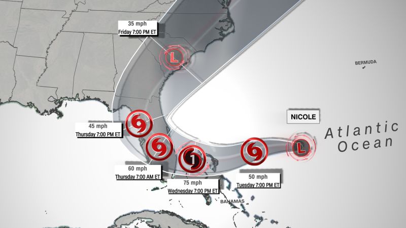
A powerful storm packing torrential rain and damaging winds is on track to slam Florida’s east coast Thursday as a Category 1 hurricane, with scattered showers due to start Tuesday afternoon – as voters head to the polls for the midterms.
Subtropical Storm Nicole is expected to make landfall early Thursday morning above West Palm Beach, CNN meteorologist Robert Shackelford said, as many across Florida continue to endure the aftermath of Hurricane Ian.
“Dont let the ‘sub’ fool you. #Nicole is a formidable storm that will have major impacts all along the southeastern U.S. coastline, not only near the center. Coastal flooding, large waves and rip currents will extend from the tip of FL to NC,” the National Weather Service tweeted.
Churning early Tuesday 385 miles east-northeast of the northwestern Bahamas, Nicole is strengthening and transitioning into a tropical storm, then starting Wednesday due to produce heavy rain that could lead to dangerous storm surge and high winds, said Jamie Rhome, the acting director of the National Hurricane Center.
It is projected to be a strong tropical storm or a Category 1 hurricane by the time it reaches Florida by Wednesday evening into Thursday morning, Rhome said Monday in a video briefing posted online.
Up to 7 inches of rain and storm surge that could rise up to 5 feet along the coast, combined with high winds, are mainly forecast for Wednesday evening and Thursday.
“The storm surge will be accompanied by large and damaging waves. Residents in the warning area should listen to advice given by local officials,” the hurricane center said.
The storm is not expected to intensify rapidly like Ian did in late September before killing at least 120 of people in Florida and destroying communities still reeling from the destruction.
“We’re not forecasting a major hurricane,” Rhome said. “Again, not an Ian situation, but still a potentially impactful system.”
More than 16 million people are under a tropical storm warning – with conditions expected in the zone within 36 hours – from Hallandale Beach, Florida, north to Altamaha Sound, Georgia, plus Lake Okeechobee in southern Florida, Shackelford said. And along the state’s west coast – from north of Bonita Beach to the Ochlockonee River – places slammed by Ian are now under tropical storm watches.
More than 5 million people are under a storm surge warning from North Palm Beach, Florida, north to Altamaha Sound, Georgia, including the mouth of the St. Johns River to Georgetown, he said.
And a hurricane watch, with conditions expected within 48 hours, is in place for nearly 9 million people along the east coast of Florida, from just north of Miami to the Space Coast and including Fort Lauderdale, West Palm Beach, Cape Canaveral and Melbourne, Shackelford said.
The mayor of Miami-Dade County urged residents to prepare.
“Residents and visitors should monitor the forecast and make sure their storm kit is up-to-date,” Mayor Daniella Levine Cava said online. “We’re taking all needed precautions to prepare for potential flooding and power outages.”
Miami-Dade County officials are not expecting the storm to impact Election Day, Levine Cava said.


